Imager
Most instruments that orbit the Earth can produce pictures, but an imager is an instrument designed specifically to do that. Typically it has more spatial resolution than other instruments (that is, it can see smaller features on the surface), and it also collects energy in only a small part of the electromagnetic spectrum. Many imagers have channels in red, green, and blue light, which can be used to reconstruct true color imagery of Earth - as a person would see it. Many also have some other channels, which can be used to produce false color images that bring out specific features of interest. For more information, see an introduction to remote sensing.
Passive Remote Sensing
Passive sensors include different types of radiometers and spectrometers. Most passive systems used in remote sensing applications operate in the visible, infrared, thermal infrared, and microwave portions of the electromagnetic spectrum. Passive remote sensors include the following:
- Accelerometer : An instrument that measures acceleration (change in velocity per unit time). There are two general types of accelerometers. One measures translational accelerations (changes in linear motions in one or more dimensions), and the other measures angular accelerations (changes in rotation rate per unit time).
- Hyperspectral radiometer — An advanced multispectral sensor that detects hundreds of very narrow spectral bands throughout the visible, near-infrared, and mid-infrared portions of the electromagnetic spectrum. This sensor’s very high spectral resolution facilitates fine discrimination between different targets based on their spectral response in each of the narrow bands.
- Imaging radiometer : A radiometer that has a scanning capability to provide a two-dimensional array of pixels from which an image may be produced. Scanning can be performed mechanically or electronically by using an array of detectors.
- Radiometer : An instrument that quantitatively measures the intensity of electromagnetic radiation in some bands within the spectrum. Usually, a radiometer is further identified by the portion of the spectrum it covers; for example, visible, infrared, or microwave.
- Sounder : An instrument that measures vertical distributions of atmospheric parameters such as temperature, pressure, and composition from multispectral information.
- Spectrometer : A device that is designed to detect, measure, and analyze the spectral content of incident electromagnetic radiation. Conventional imaging spectrometers use gratings or prisms to disperse the radiation for spectral discrimination.
- Spectroradiometer : A radiometer that measures the intensity of radiation in multiple wavelength bands (i.e., multispectral). Many times the bands are of high-spectral resolution, designed for remotely sensing specific geophysical parameters.

Optical Depth
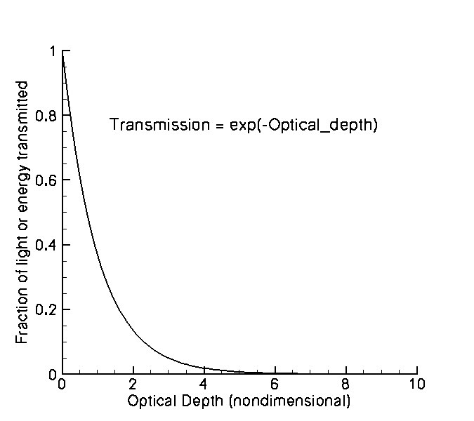
The optical depth is a measure of the visual or optical thickness of a cloud; that is, of the reduction of light or energy transmitted through the cloud due to interactions with the cloud particles. Optical depth is much more significant to Earth's energy budget than the physical thickness of cloud layers. Unlike height, it is not measured in meters or feet; but is nondimensional. An optical depth below 3 is considered to be thin. Anything above 10 is definitely thick. The same term is also used to describe the optical depth of aerosol (dust, smoke, etc) layers.

Kelvin
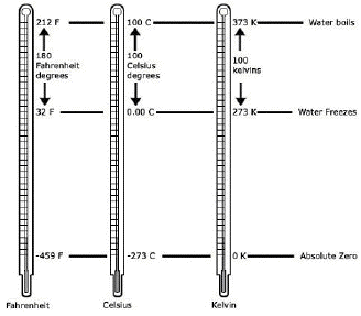
An absolute temperature scale invented in the 1800's by William Thompson, Lord Kelvin. It places the zero point of the scale at absolute zero, the temperature which scientists believe is the lowest possible. All molecular motion would stop there. A Kelvin degree is the same size as a Celsius degree, so the two scales simply have a constant offset.
